All Frequently Asked Questions
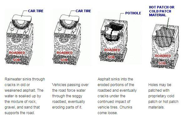
Potholes are holes in the roadway that vary in size and shape. They are caused by the expansion and contraction of ground water after the water has entered into the ground under the pavement. When water freezes, it expands.
To report a pothole or roadway defect in Summit County, call the Summit County Engineer's Public Services Department at (330) 643-2860.The office is open Monday - Friday, 7:30 A.M. – 4:00 P.M. We also have a 24/7 reporting system to gather information reports of roadway problems.
To ensure that the repairs you are requesting are handled in a timely and efficient manner, please have the following information available at the time of your call:
- Your name. (Optional)
- Your address and daytime phone number. (It is important that you provide a contact number in the event more information is needed.)
- The location of the pothole, including the nearest cross street and/or address.
- A description of the problem. (There are other types of road defects that may appear as a pothole, but may require more intensive repairs.)
- Any other pertinent information that may need to be relayed to the crews about the area or the problem.
After we have received notification of a pothole, one of our maintenance foremen will schedule a site visit to determine the size and priority of the problem area so the properly sized and properly equipped work crew can be scheduled to make the needed repairs. It is the Summit County Engineer's goal to have every pothole complaint reviewed by the next work day and to have the repairs scheduled as soon as possible.
According to the Ohio Revised Code, a County Engineer in the State of Ohio must have professional certificates as both a Registered Professional Engineer (P.E.) and a Registered Professional Surveyor (P.S.):
§ 315.02 Text of Statute No person holding the office of clerk of the court of common pleas, sheriff, county treasurer, or county recorder is eligible to hold the office of county engineer. No person is eligible in any county as a candidate for such office or shall be elected or appointed thereto unless he is a registered professional engineer and a registered surveyor, licensed to practice in this state.
View the qualifications needed to become a Professional Engineer and to become a Professional Surveyor (Chapter 4733.11 - Qualifications) .
Yes, but only if the animal is in the right-of-way on a County road or highway. You can call the Summit County Engineer the Public Services Department at 330-643-2860 for removal information. If it is on a city street (e.g. City of Akron) please call the city’s street or road maintenance department.
Speed limits on County roads are set by state law and the lowering of speed limits must be approved by the Ohio Department of Transportation (ODOT). ODOT requires a speed study be performed and the results must warrant a reduction in the speed limit. It is extremely rare to get a speed limit reduced under these requirements. Please find more information from ODOT here.
Potholes are holes in the roadway that vary in size and shape. They are caused by the expansion and contraction of ground water after the water has entered into the ground under the pavement. When water freezes, it expands. Think of when ice cubes are made. A tray full of water is put into the freezer, and when you remove the tray from the freezer, you will notice the water has expanded. This same effect happens when water gets into the ground under the pavement. If it has a chance to freeze, it will take up more space under the pavement, and the pavement will expand, bend, and crack, which weakens the material pavement. Then when ice melts, the pavement contracts and leaves gaps or voids in the surface under the pavement, where water can get in and be trapped. If the water freezes and thaws over and over, the pavement will weaken and continue cracking.
As the weight of cars and trucks pass over the weak spot in the road, pieces of the roadway material weaken, which will cause the material to be displaced or broken down from the weight, creating the pothole.
What happens when salt is brought into the picture? Water will freeze at 32 degrees Fahrenheit. When salt is used, it lowers the temperature that water will freeze. This creates an artificial freeze-thaw cycle that permits more occurrences of the damaging cycle to occur. This happens more often in the spring because of the melting that takes place and because the temperatures fluctuating above and below the freezing point very frequently.
Contact Surveyor Walt Schostak with questions regarding all mylars related to the County Engineer via the online Contact Form or at (330) 643-8560.
Unfortunately state law doesn't have an easy solution for drainage issues, especially those among private property owners. If requesting your neighbor to make drainage improvements to alleviate run-off doesn't work, the dispute will have to be settled in court via a civil lawsuit. The plaintiff will have to argue that there is more run-off on their property than before and that it adversely affects their land.
The County Engineer's office generally only provides survey services for County and township improvement projects. There are a number of private Professional Surveyors, registered in the State of Ohio, who provide surveying services for private properties.
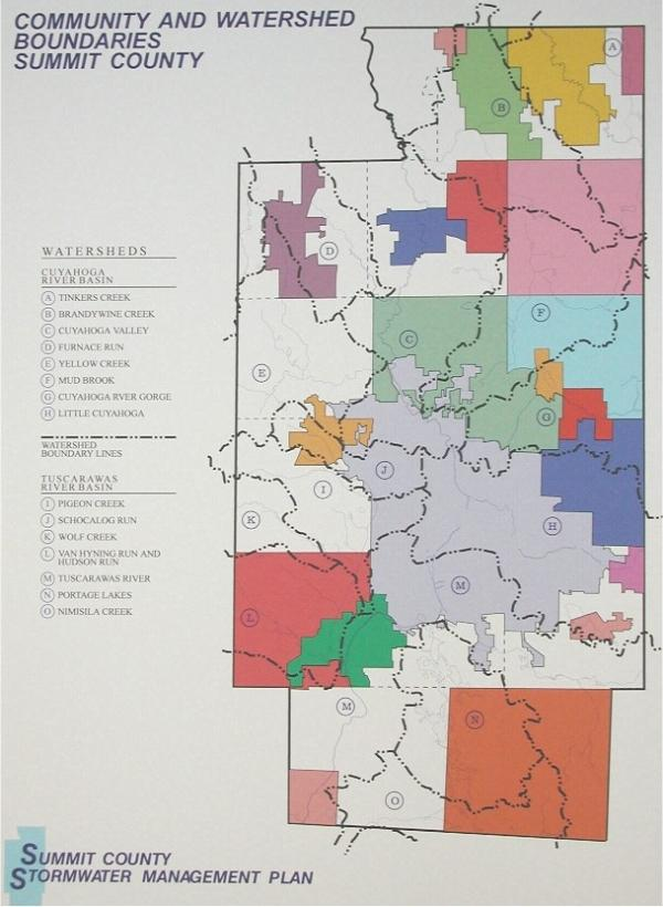
Some of the rain is absorbed by the ground where it falls. This portion of the rain provides water to the roots of plants and adds to our ground water supply. The rest of the rain becomes storm water, which flows across the ground, and from roofs and parking lots to swales, gutters, streams, storm sewers, rivers, lakes and ponds. For every stream, river, lake and pond there is a territory from which the storm water flows. This territory is called its watershed.
Rain falls on every part of the watershed. Storm water flows from the higher portions of the watershed to the lower portions of the watershed and to the streams, rivers, lakes and ponds. How much, how fast and how clean the water is when it reaches the lower levels of the watershed and the streams, rivers, lakes and ponds depends on the conditions of the ground that it flows across. Every part of the watershed affects another part of the watershed.
There are ways to control how much, how fast and how clean the storm water is as it flows across the watershed. Since every part of a watershed affects other parts of the watershed, these controls are most effective if they are coordinated throughout the watershed. Watershed boundaries cross community boundaries, such as cities, counties, villages and townships. Watershed-based storm water management requires cooperation between neighboring communities.
SCE created the below checklist for residents and builders who are constructing new homes. The checklist must be submitted with all site plans that are required to be reviewed by the County Engineer's Office.
- New Home Construction Checklist (PDF, 180.0k)
Copies of the county map are available in the lobby of our Main Office building. You can request a map or order maps from the Engineer's Office by calling (330) 643-2860 or by completing the map order form from this website on the contact page.
Maps are also available in several locations, including public libraries and at our kiosk during the Summit County Fair. A PDF of the most recent Summit County map is below.
- Summit County Map PDF (PDF, 12315.1k)
Zoning information is provided to residents from their respective township, city or village zoning department. Please visit the local government's webpage for zoning information.
Please contact the Building Standards Division at the Summit County Department of Community & Economic Development if you would like more information about Building Permits.
Please note that all projects located within the City of Akron must contact Akron Plans and Permits at (330) 630-7305 or (330) 375-2010 for compliance requirements.
The list of signals and road maintenance responsbilities are attached below. These lists are subject to change.
- Roadway General Maintenance Responsibilities Road List (PDF, 248.4k)
- Traffic Signal Responsibility (PDF, 7.1k)
- Snow and Ice Responsibilities (PDF, 296.6k)
House numbering is no longer overseen by the Summit County Engineer's Office. House Numbering responsibilities are now under the Summit County Executive's Office Department of Community and Economic Development, Planning and GIS Department. Requests for addressing can be made online here.
The City of Fairlawn and the City of Akron assign their own house numbers.
Ditch questions/assistance
Please contact the Public Services Department with questions about township roads and highways ditch maintenance by using the Contact Form or call us at (330) 643-2860.
Employment at the Summit County Engineer
The Personnel/Human Resources Section handles all employment opportunities at the Summit County Engineer's Office. You can contact Office Manager for Personnel via the Contact Form or call (330) 643-8062. You can also view all Summit County Job Postings here.
Underground utilities - Is there one number I can call to have them marked?
Yes, you can call the Ohio Utilities Protection Service at 1 (800) 362-2764.
Underground mine information
The Ohio Department of Natural Resources - Mineral Resources Management information line is (614) 265-6633.
Stormwater and Drainage questions
Contact David Koontz, Surface Water Management District engineer and subdivision stormwater engineer, with inquires relating to stormwater management issues. He can be reached at (330) 643-8537 or via the contact form.
A sign that is badly damaged or missing on a County road
Contact the Engineer's Public Services Department with comments concerning signage on County roads via the Contact Form or call (330) 643-2860.
Sanitary sewers in my township
For township sanitary sewer information call the Summit County Department of Sanitary Sewer Services at (330) 926-2435. For other sewer questions in cities or villages, please contact the local municipality.
Road record surveys
Contact Surveying with questions regarding road record surveys at the Engineer's office via the Contact Page or at (330) 643-8560. Records are also available online via the links posted below this section.
Geographic Information Systems (GIS) and drawings
Contact the Summit County Department of Community and Economic Development Department with any questions and requests regarding GIS.
Floodplain mapping and flood zones
Please contact the Summit County Department of Development - Building Standards (330-630-7280)
Expressway sign, ramp and roadway questions
For questions regarding signs and roadways on state routes, call the Ohio Department of Transportation District 4 office at 1 (800) 603-1054.
- Plats & Plans for Surveyors (Website)
- Summit County Engineer Road Records Finder (Website)
- Survey Tools (Website)
It depends! Check for temporary marking colors or flags to determine if they are temporary survey markings or utility markings. Generally:
- White: Proposed excavation limits or routes.
- Pink: Temporary survey markings, or safety markers for unidentified lines.
- Red: Electric power lines, cables, conduit, and lighting cables.
- Yellow: Gas, oil, steam, petroleum, or other gaseous/flammable materials.
- Orange: Communications, alarm/signal lines, telephone lines, or cable TV conduits.
- Blue: Potable drinking water lines.
- Green: Sewer and drain lines.
- Purple: Reclaimed water, irrigation, and slurry lines
A portion of all property lines run along the centerline or the right-of-way of a road. Property corners bordering a road are usually marked with survey monuments, sometimes referred to as "pins", set at the intersection of the property lines and the road right-of-way even though a property line may extend to the centerline of the road. Since survey monuments that define the center of a road are sometimes lost or destroyed, the next best evidence of the road boundary may be the alignment of property corners along the road right-of-way. Most modern road rights-of-way are 50 or 60 feet in total width, so that would generally place the right-of-way within the front yard area. Although survey monuments are generally set flush with the surface, they tend to be covered with dirt over time. When this happens, a metal detector is used to locate the monument for recovery. Then the area is carefully excavated to expose the "pin". After measurements are taken, the hole is filled and the area is carefully restored to its original condition. Recovering and measuring to survey monuments located at other property corners away from the road is also necessary to determine property lines that relate to public improvement projects that extend beyond the road right-of-way. Examples of these projects may be improvements of drainage courses or government properties.
In addition, utilities and private property owners often engage the services of surveyors and utility locaters for their own projects. Some projects will be new construction and should have been issued a permit by the road owner. In that case, call the government that owns and maintains the road to get details on the construction work. There will be instances where gas, electric, and telecommunications companies will be working under a blanket permit for standard repair projects or emergency repairs and will not have any additional information on file with the local government agency. Best practice is for utilities and broadband companies to notify residents of upcoming work, but that is not always the reality. We will do our best to answer your questions at 330-643-2860.
Find a list of county owned roads here: https://www.summitengineer.net/files/11969/file/general-maintenance-responsibilities-2020.pdf
A large amount of surveying is performed by private surveyors to establish property lines for land sale or development. Signs of surveying are thin wooden stakes about 3 feet tall with pink ribbon or flagging and/or pink painted numbers or letters on road pavement. The Summit County Engineer (SCE) provides survey services for County and township improvement projects. These survey services are performed by a consultant and/or the SCE Survey Section. SCE surveyors work out of white vehicles with green stripes and SCE logos on the side and a yellow safety light on the roof. Employees carry SCE identification cards with them. Most of SCE survey work is performed within the road right-of-way to determine the centerline. The centerline of right-of-way is of great importance to SCE projects.
The County Engineer is responsible for the maintenance of county roads in townships, various bridges throughout the county, roadway drainage, the Surface Water Management District, and much more.